How many people get to live their dreams? I am..........!

This is my story from the time when Capt'n John and I first decided to sail around the big block, to circumnavigate this great land of ours, AUSTRALIA.


Sunday, 18 August 2013

Rainy Days in Purulba Creek, Prince Regent River

Thursday 20th June 2013
Rainy Days in Purulba Creek, Prince Regent River

I had woken to more spots of rain on the canvas and a bad headache but the rain didn’t last for very long. 0530 MrJ and I were on our way again; catching the tide to go into the Prince Regent River. Once in the river there were sandbars, reefs and rocky mangrove islands to look out for, all of which have been accurately marked in the Freemantle Sailing Club Guide.


raining in the creek


Our first anchorage was a mile up the second large creek, Purulba Creek past the big sandbar at the mouth on the northern side of the river. Here AR was sitting right under another beautiful rocky cliff face. A beautiful calm anchorage! (15'29.726S - 125'09.993E)


refueling the boat


This day I had) before breakfast moved house (location), after breakfast cleaned the floors, (breakfast is important) and then went to the shop. What did I get? I picked up three tins of peaches and four tins of baked beans. I did think about some bread but that could wait until the next day. What shop? Why my shop, my shop in the mid ships bilge. ;o)) Curried fish and rice for dinner!

The weather was still very overcast and coolish, cool enough for me to be a light long sleeve shirt with my shorts and in the evening I had to put on a pair of light long pants. We also needed more than just the sheets on the bed at night. This must be the winter part of the Kimberley’s!

The sun came out on the last day.
and we were able to have showers on deck
the sun came out on the last day

Into the Saint George Basin

Wednesday 19th June 2013
Today was Cassandra’s birthday – happy birthday number one child!

Into the Saint George Basin and the Prince Regent River

Going by the weather reports on the HF radio every day they were predicting strong winds for the next few days. MrJ and I need a better anchorage than Ivy Cove for these conditions. So away we sailed, making a run for King George Basin and the Prince Regent River.
0830 we were passing Bat Island. MrJ was out front making an adjustment to the mainsail when the fish line went. I ran over to stop it, making a mess in the line. I was thinking bloody seaweed again!  But no! MrJ had to take over the hauling in to bring in a small bronze whaler shark. The shark had all but swallowed the lure so we had no other choice but to kill the shark and keep it for food. Fish for dinner! Just like the Hake or whatever we used to get in the fish shop years ago. Same thing; shark!

I can't catch a bloody thing.....................!

1130 as were begin our approach to King George Basin; we had passed Cape Wellington and were heading towards the passage between the mainland and Uwins Island when we see another boat, a tourist motor boat Oceanic Discoverer, coming out and then there was another motor boat heading in from behind Uwins Island. Bit like Pitt Street! The motor boats were way too fast for us!
The sky was very overcast and we even had a light shower of rain on the sail down. This overcast not quite drizzly weather was giving the scenery a blue feel: blue still water, blue grey sky and variations of blue through the land-form. Just beautiful!

We had caught the bottom of the tide as AR entered the narrow passage into the St George Basin. With MrJ at the helm and me keeping a good lookout; we were expecting lots of turbulence and whirlpools as was reported in all the guide books. But our passage in was smooth as!

Motoring through the St George Basin there were stunning views St Patrick's and St Andrews Islands with Mt Waterloo and Mt Trafalgar as the backdrops. We anchor in the SW of the Basin, just outside a creek and under the shadow of a huge headland red stone cliff. The afternoon had brought mixed winds and some light rain with a bit of slop across the water but we were settled for the night and both sleep good. And we had fish for dinner!

Friday, 16 August 2013

Boab Trees

Coronation Islands
 Tuesday 18th June 2013
Boab Trees at Ivy Cove on Glauert Island in the Coronation Islands and Careening Bay Port Nelson
morning in York Sound
From our uncomfortable anchorage in York Sound (maybe we should have anchored on the other side where another cat and a schooner had anchored. (sure sign? der!) MrJ and I motor sailed AR around the corner through the Anderson Islands. We were heading for another place, an anchorage on the northern side of the head of the Prince Frederick Harbour where we had been told about some more crystals. To get to this special place we were negotiating our way through a few narrow channels between the islands until there was a sudden drop in the depths. Not liking this shallowness (meaning possible reefs) and the southerly winds had kicked up the sea which meant even if we had been able to get through the shallows AR would have been on a lee shore anchorage. No thanks!
Hello...........


MrJ and I gave this anchorage a miss, turned AR out to sea and headed for Careen Cove at the bottom of Port Nelson. Careening Cove anchorage (15’06.148S – 125’00.304E) was a good stop-over, a bit rollie in the fresh breeze.
In Careening Bay Philip Parker King carved HMC Mermaid 1820 into a boab tree during his survey of Australia. It is still clearly visible about 100m up the tidal creek that enters the bay. His Britannic Majesty's Cutter Mermaid was launched in Calcutta. India on December 23, 1816. She was 84 tons, 56ft LOA, had a beam of 18ft 6in and draft of 9ft. She was built in solid teak with English cordage and sheaved with 18oz copper. Purchased by Governor Macquarie for f200 and assigned to Philip Parker King for the survey of the northwest. The Mermaid spent sixteen days at Careening Bay while repairs were carried out on the keel, stern post, rudder connections, garboards track and fastenings. Unfortunately, iron nails had been used in her building. King’s tree is now overgrown with vines and the creek has no water.


Also on shore closer to the beach, carved into another Boab Trees we found the names of other boats that had been this way before. One in particular interest to us was the boat name Tradewinds, Tradewinds 3 + 4 in 2000 + 2011. Tradewinds is the name of Barry and Robyn’s boat but I can’t remember which number they have and for how long they have had their boat. I do know that they have been this way before. I wonder?

Back on board SR MrJ and I make passage for Ivy Cove on Glauert Island which is part of the Coronation Islands just north of Careening Cove. There is a deep navigable passage between Gray and Glauert Islands. We keep to the centre with a good lookout for any hidden rocks or sandbars. On the east side of this passage was the Ivy Cove anchorage (15'03.3'5 124'58'E) where it was possible to get out of the strong tidal flow and anchor in thick mud.


There was a beautiful sandy beach and ashore a large boab tree on which the inscription Ivy 19.10.1890 or 91 (uncertain) has been carved. Ivy was a pearling schooner working in the area under the command of Captain Biddles.


 The winds had turned more to the north, NW sea breezes had settled in once again and the Ivy Cove anchorage was for SE winds and so a very sloppy sea came down the channel and into the bay causing small wavelets across the bay making AR do her rocking act. MrJ and I had decided to get out in the tinny for a spot of fishing along the thing mangrove shoreline. This turned out not to be such a good idea with sloppy water and getting back on board was a bit of a trial too with AR rocking and bobbing one way and the tinny bouncing all over the place. Reminded me of when we were in Hiva Oa or Balboa in Panama. No fun at all!


However while in Ivy Cove we did not see the reported resident crocodile that had been blamed for chewing an inflatable dinghy that had been left tied astern. And another bit of useful or useless information about this area - The nuts from the Cycad trees are poisonous. Just so as you know that now!

Wednesday, 14 August 2013

Rock Art at Bigge Island

morning across Prudhoe Island

leaving Shelter Bay

Monday 17th June 2013
Rock Art at Bigge Island –
Montague Sound and a Lumpy Night in York Sound

It took us exactly two hours to sail from Shelter Bay at Prudhoe Island to Wary Bay on the NW side of Bigge Island some 8n/m away. (14’28.071E – 125’08.669S) This was only a stop-off, stopping just long enough to go exploring and then we were on our way again. The reason for the stop-off; Bigge Island is famous for some amazing rock art paintings known as the Wandjina figures that are spread over many sites.


track on the beach
To the Aboriginal people who live in the Central, Northern and East Kimberley region including Mitchell Plateau and King Edward River areas of Western Australia the Wandjina has a deep and meaningful relationship with their heritage and their culture. The Wandjina has for many years appeared on bark coolamons which were used for food gathering and for cradles for newborn babies, ceremonial boomerangs and shields and a myriad of symbolic artifacts - the Wandjina is part of the lives of the tribes who have for so many years lived, hunted and survived in the country of the Wandjina rock art.

In Aboriginal culture the Wandjina is the Rain Spirit of the Wunambal, Wororra and Ngarinyin language people, the controller of the Seasons, the bringer of rain which equals water which equals life itself. Then it says that the Earth is hot and that it breathes; the Earth it breathes, it's a steam blow up, and it gives cloud to give rain. Rain gives fruit, and everything grows, and the trees and the grass to feed other things, kangaroos and birds and everything. With the completion of their earthly tasks, each of the Wandjina turned into a rock face image. There the Wandjina spirits continue to live.
figures with smoking pipes
The Wandjina figures are strange, majestic creatures usually painted against a white background. An oval band encircles the face except for a break at the chin and from the outer edge of the head, lines radiate out. They are often shown wearing a headband; the eyes and nose form one unit with lashes encircling both eyes and they are rarely given a mouth. The body when there is one is filled with parallel stripes down the arms and legs. Long lines coming out from the hair are the feathers which Wandjinas wore and the lightning which they control.

boats


Wandjina ceremonies, to ensure the timely beginning of the monsoon wet season and sufficient rainfall were held during December and January, following which the rains usually begin. The figures are generally drawn surrounded by the totemic beings and creatures associated with them, on which they depend for sustenance, and these caves and rock shelters become a focus of tribal religion and ritual action.


Aboriginal people believe that if the Wandjina are offended then they will take their revenge by calling up lightning to strike the offender dead or the rain to flood the land and drown the people or the cyclone with its winds to devastate the country. These are the powers which the Wandjinas can use. Aboriginal culture teaches it is possible for new life to emanate from the figures adorning the cave walls, to re-enter the physical world as unborn children. Such places are sites to which local Aborigines have a deeply spiritual attachment. These Wandjina are seen to have considerable powers and the Aborigines are careful to observe a certain amount of protocol when they approach the paintings, fearing that if they do not, the spirits might take their revenge. This protocol normally consists of calling out to the Wandjinas from several yards' distance, to tell them a party is approaching and will not harm the paintings. Although the paintings represent the bodies of the dead Wandjinas, the Aborigines believe the spirits of the Wandjinas live on in much the same way as they believe the spirits of human beings continue to exist after their death.
Wary Bay was a site for these special Wandjina figure paintings and one in particular, Father Kaiara.

the labyrinth of caves
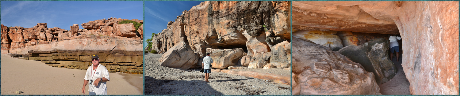
The rock art sites at Wary Bay were located in what they call mini gorges in the rock cliffs at the south-western end of the beach. To me the mini gorges were like interlinking small caves. The majority of these rock art paintings were in excellent condition having been protected from the ravages of the elements. The face of the Father Kaiara from the Wary Bay gallery is probably one of the most spectacular and frequently published photos of aboriginal rock art in the Kimberley.

The Wandjina figures on Bigge Island are known as Kaiaira or Sea Wandjinas; they are close to the sea not up on high cliffs. These Wandjina figures were distinctive with their halos around the head of each figure. These halos represent clouds as the Wandjina are cloud spirits intimately linked to the weather, water and life. The Wandjina figures were painted by the Wunambal people and their legends tell us these Wandjinas were brought by the waterspout from the sea.


Father Kaiara
The figure of Father Kaiara was an imposing figure, larger than me or MrJ; he was watching over the sea to the northwest through his dark, deeply engraved eyes. The paintings of his children or followers were varied in form, some of whom could have been early European visitors such as the Dutch, English, or Portuguese sailors of the 1600’s as images of sailing ships and figures smoking pipes were also evident. Or were the figures of later visitors, for example the French sailors of Baudin's expedition of the early 1800’s? We will probably never know!
large turtle nest and tracks

On the way back to the tinny MrJ and I walked further along the beach and came upon some freshly made turtle egg nest. I knew that these nests were fresh as the track of the turtles were still fresh and had not been washed by the sea or windblown. Maybe the tracks were as fresh as the night before?
How long does it take for the eggs to hatch? This I will have to read up about! (Gestation: 6-10 weeks.)

What a magical place was this Bigge Island and I was so thankful for having been able to experience its magic.
MrJ tries his hand at fishing again

anchorage in York Sound
 MrJ and I sailed away from Wary Bay down the western side of Bigge Island, we sailed south, deep into the eastern bay of York Sound. We were heading for the inlet known as Rainforest Ravine but changed our minds, as we do, when the weather had turned. (14’54.690E – 125’16.135S) We were thinking that inside the main part of the bay around the southern point would give us better protection from the westerly winds but then as it always happens, the wind changed again to the opposite direction. And so it did and we had a sloppy anchorage and not much sleep. Sa la vie!
good night from York Sound

Sunday, 11 August 2013

The Crystal Island

taken at the first rock ledge - looking down on the bay in Prudhoe Island
Sunday 16th June 2013
The Crystal Island – Prudhoe Island Montague Sound
I had a small lie-in, not getting up till after 0600 then cooked a big Sunday breakfast and MrJ had found ABC National on the radio, short wave. He had Macca on a Sunday Morning but it didn’t last for long as the boat swung the signal dropped out.
It was not long after I had cleaned up that MrJ and I dropped the tinny to go exploring. We could see some caves high up in the rock ridge to the south. Maybe we could climb up there was our thoughts. Must have been getting over confident with our thoughts!
I can climb that
Once we had found a way of getting ashore with all the large rocks around the foreshore and the steep banks that were almost like small cliffs.
ready for the climb
Then we had the worry about the tide coming in and not securing the tinny good enough. Try as we may have; MrJ and I were not able to get to the caves we were only able to get about a third of the way stopped by large rocks, small crumbling rocks that slipped under foot and the thick Spinifex bush covering all those hidden rocks and holes to trap your feet and the cliff faces. All just too much so back down to the tinny and onto another part of the bay where the rocks were not so huge and the bank was gentle with even a bit of sand to be seen. Still we were unable to find a path to the caves at the top.
a hard climb
MrJ and I decided to go explore the northern side of the bay. We found a little inlet where there was a heap of mangroves from the shore back into a gully some low level rocks and a bit of a sandy beach. Looked just like great croc country! If there was one there I’m sure that it could see us but we could not see it. Maybe the Prudhoe Island was too far out from the mainland for crocs? I don’t think so!
the crystal bay
do you think this rock looks like a camel's head?

Anyway no croc or any signs of crocs were seen but we did see one very interesting thing. Crystals! A huge vein of quartzite crystals! I had been looking at a long vein of solid iron stone between the sandstone and the quartzite (most of the island of the Montague Sound are of sandstone and quartzite) and buried in the sandy rubble was a mixture of broken coral and shells, bits of ironstone pebbles and shards of quartzite. To my surprise some of the quartzite was in perfect crystal form. Only a few feet away were several huge veins of crystal rock. How amazing! MrJ and I collected several broken off pieces and then left the magical crystal kingdom by the sea. I do know of other places that we have been told to look for the crystals and all places are in this same area of the Kimberley’s but on the mainland.

Back on board AR MrJ and I gave both the outboard motors a clean out with a product called Salt-Away. Salt-Away could be mixed with either salt or freshwater, we put it in a large bucket of salt water and then put the bucket under the outboard propeller, turned the motor over so that the outboard sucked the Salt-Away water in through the sea suction or water inlet to clean the salt build up from inside the water pipes/hoses etc.
Do you know what happens when you start an outboard motor in a bucket of water?
I get wet!!!!!!
Later that afternoon a big aluminium motor catamaran, Orca Blue, came into Shelter Bay to anchor across the way. The fella, Stephen, came over in his large bright yellow poly plastic tinny, too big to call a dinghy for a bit of a chat. There were from Perth and on their way to Darwin to see family. Stephen did offer us the use of his mooring in Broome while he was not using it. Nice fella, maybe we will!
crystal colour in the sunset