Sailing the Magical East Coast of Tasmania
.jpg) |
| Tasman Peninsular and Tasman Island |
The Derwent
River to Freycinet Peninsular
23rd - 28th Feb 2014
Sunday:
From Hobart MrJ and I sailed out of the Derwent River, out into Storm
Bay, then out around the magnificent Cape Raoul, on up the east coast and into
the World Heritage-listed Port Arthur Historic Site, which are both part of the
Tasman National Park.
.jpg) |
| the Iron Pot, the oldest lighthouse in Australia, is off Cape Direction as you enter Storm Bay from the north. Iron Pot Lighthouse is significant for several reasons.It was the first lighthouse built in Tasmania, it is the second oldest lighthouse built in Australia, it is the oldest original tower in Australia, it was the first to utilise a locally made optic, and was the first Australian lighthouse to use solar power. |
The swell lifted as we were approaching Cape Raoul, a 300-metre high
cliff; MrJ was trying to get in as close as possible so that we could get some
good photo of the towering rock formations that were the end of the cape. We
also had to content with the rebound off the magnificent cliff faces. I had one
hand tightly clinging to the boat and the other hand was firmly gripped to my
camera as I balanced on the bouncing side deck dodging sea spray and hoping
that at least one of my photos would turn out. Such dramatic beauty!
 |
| Cape Raoul - the perfect place to rock climb |
MrJ and I rounded the beautiful Cape Raoul and headed for the Port
Arthur entrance. On approach to the historic penal colony site in Mason Cove we
passed by The Isle of the Dead on our port side then headed a little further
south, just past Commandants Point to drop anchor in Carnarvon Bay. I was
totally surprise by all the boat moorings in Mason Cove not giving me that
sense of past that I had once felt on my first visit to Port Arthur some
15years before.
 |
| Port Arthur in the 1870's Convict labourers in Australia in 1926 |
The Isle of the
Dead
is located in the harbour off Port Arthur. Between 1833 and 1877 around
one thousand burials took place there.
.jpg) |
| into Port Arthur - passing The Isle of the Dead |
The Island of the Dead was the destination for all who died inside
the prison camps. The island was originally name Opossum Island after a vessel,
the Opossum, sought shelter near the island in 1827. It became the burial place
for Port Arthur in 1831 (only months after the establishment of the settlement)
and almost immediately was divided into free settler and convict burial
grounds. At this time it was known simply as Dead Island.
+(1100x534).jpg) |
| boats moored in Mason Cove |
Monday:
The weather had taken a sour turn, overcast and beginning to drizzle
with rain. This was a good chance to stay wrapped up inside and get some
writing done. No rest for the wicked as the saying goes; the wind was turning
to the north which meant that we had to change anchorage late in the day. It
was just before dark in our new anchorage, Stewarts Bay, around Fryingpan Point
to the north that the anchor winch died and it was not going to recover.
Buggar!
.jpg) |
| misty rain all day |
Tuesday:
Firstly MrJ and I went ashore and took the long walk through a resort
complex (uphill and down dale) to the grounds of the Port Arthur penal colony
ruins. Secondly, upon our return, by the shorter route, along the road and
through the campground we attempted to fix the anchor winch motor but to no
avail. It was beyond resurrection.
.jpg) |
| Port Arthur Penal Colony |
World
Heritage-listed Port Arthur Historic Site is one of the best-preserved convict settlements
in Australia and among the most significant convict era sites in the world. Port
Arthur was established in the 1830s as a penal settlement and remains a
physical chronicle of a dramatic part of Australia's history, an open air
museum.
 |
| my collection of impressions |
 |
| Inside the separate prison |
A brutal penal colony located on the Tasman Peninsula, Port Arthur was
home for many of Australia's early convicts. It was here that many transported
and re-offending convicts spent their days. Its isolation and formidable
geography gave it a feared reputation.
After transportation of convicts ended, the buildings were used for
many years to accommodate convict invalids, paupers and 'lunatics'. The site
has continued to evolve through phases of significant development, decline and
change, bushfires, demolitions, constructions, major landscape alterations and
restoration work.
The buildings, ruins and other site features that remain today are now
a major tourist attraction and Australia's most vivid and well-known reminder
of its convict beginnings.
+copy.jpg) |
The Hospital was made up of wards, kitchen,
baking room, laundry and morgue. As the convicts of Port Arthur worked in heavy
industries such as timber-getting, accident victims at the hospital were
common. The hospital was staffed by a doctor and a number of untrained convict
orderlies. In the 1890s, the hospital building was sold to the Catholic Church,
but was unfortunately burnt in the 1895 and 1897 fires.
|
The tragic death of 35 people at a gunman's hand in 1996 added another
emotionally powerful layer to the history of the place and gave it a new
national significance as the place that led to Australia's tightened gun laws.
 |
| the government housing for officers and officals |
Hundreds of thousands of visitors each year are drawn to experience the
once brutal penal settlement, which sits quietly on the Tasman Peninsula
surrounded by verdant lawns and English oaks.
 |
| the English style gardens |
But I didn’t experience that tragic overwhelming emotional feeling like
on my first visit. Maybe because I had been before or maybe it was the extent
of the commercial side (a major tourist attraction) that greeted me from the
start. Who knows! I still think Port Arthur is beautiful and darkly tragic.
Another
impressive building in the complex is the church which stands on the hill next
to the Government Cottage looking down across Masons Cove towards the Isle of
the Dead. This famous landmark was built around 1836-37 and was probably based
on a design by the Deputy Commissariat Officer, Thomas Lempriere, and the
convict architect, Henry Laing. It was never named nor consecrated.
Next to the
Commandant's House is the Guard Tower and Military Complex, perhaps the most
architecturally sophisticated building at Port Arthur. This building, now in
ruins, was the third military complex built at the colony. The first, a timber
building, was replaced in 1841 by a brick structure which, in turn, was
replaced by this two storey barracks which was completed in 1847. The most
prominent remnant of a building is the Guard Tower which was built in 1836 with
stones specially shaped by the teenage convicts at Point Puer.
 |
| Port Arthur |
Wednesday:
At first light MrJ and I quietly slipped ALANA ROSE quietly out of Port
Arthur, past The Isle of the Dead, saying our sad farewells to the ghosts and
the memories of this god-forsaken institution.
 |
| morning in Stewarts Bay |
 |
| I helped to undo the bolts - MrJ climbed in the hold to undo bolts from the underside - MrJ lifted the winch out - the winch motor was stuff |
After MrJ manually hand levered 45 metres of chain in we were sailing for an anchorage on Maria Island.
After leaving Port Arthur we motor-sailed
around the headlands of Tasman Island, Tasman Peninsula, Cape Pillar and
Cathedral Rock.; another incredible sight, a coastal wilderness of unspoiled
coastline. I saw soaring cliffs, pillars of rock and misty sea spray through
early morning golden sun light.
 |
| approaching Tasman Peninsular and Tasman Island as the sun greets us |
 |
| morning sun and ocean mist |
The Tasman Peninsula is well known for its rugged eastern coastline. It
can lay claim to the highest sea cliffs in the southern hemisphere, rising
300 m (980 ft) above the Tasman Sea, the spectacular dolerite cliffs
at Cape Pillar and towering sea stacks such as Cathedral Rock, the Totem Pole
and Candlestick. Here I was witnessing the tremendous erosive power of Mother
Nature.
Throughout the rock climbing fraternity Cape Pillar also holds the unofficial
title of ″The Scariest Cliff in the Known Universe.″ http://www.thesarvo.com/confluence/display/thesarvo/Cape+Pillar
 |
| Cape Pillar - The Scariest Cliff in the Known Universe |
 |
| is where Albatross soar |
The Tasman Island Lighthouse was built in 1906, is one of the highest in
Australia. The light is sited on the highest point of Tasman Island and is
known for the height, 250 metres, and steepness of its cliffs. When the light was first established, the
winds were so fierce that the steel tower would shudder, fracturing the lamps
mantles and putting the light out. It is constructed of cast-iron plates,
circular in section, bolted together and positioned on a concrete base 26
metres in diameter.
The keepers' cottages also built in 1906 are solid brick. Sheds for
wood and coal etc were all joined under the same roof as the cottage for
protection from the fierce weather that frequents the island in winter.
.jpg) |
| Tasman Island Lighthouse and Keeper's Cottages |
Tasman Island is one of the two most isolated light stations in
Australia, and for that reason, was extremely unpopular with all keepers. Once thickly forested, it is now almost bare as the result of the
cutting of trees for firewood and of two severe fires. At Tasman Island in South-eastern Tasmania light keepers' stores and
other goods have to be transferred from the lighthouse steamer to a launch
which conveys them to a flying fox (a conveyor suspended from an overhead
wire). The flying fox extends for some hundreds of feet from a rock about
twenty-five feet above sea level to a ledge on the island about a hundred feet
above the sea. From there the goods are hauled by an engine-driven winch along
a steep tramline up a cliff to an elevation of about 700 feet. Thence they are
transferred to a horse-drawn tramway which takes them on the final stage to the
lighthouse, situated about 700 feet above sea level.
 |
| in this collage of photos - Stores, keepers and their families were all brought on and off Tasman Island via this flying fox. B&W photo - A Cape Class supply ship with the tramway and flying fox in background. Note the small boat just below the flying fox. (two photos courtesy: Australian Maritime Safety Authority) |
Often supply vessels would have to make repeated attempts to land
supplies due to inclement weather.
The other point of access to the island was the Zigzag, named for the
access path down the cliffs. It was used for by small boats for landing the
mail, urgent supplies and medical assistance. Pigeons were used for the first
20 years for emergency messages. Fencing surrounded the lighthouse and keepers' complex to protect stock
and small children from it's dangerous sheer cliffs. Stock used to disappear
down the various holes and caves that dotted the island, never to be seen
again. Keepers had to very self-sufficient; they kept good gardens of both
vegetables and flowers on island's the fertile soil, they yarded, sheared and
slaughtered sheep, cut and sledded wood. Meat was supplemented at
mutton-birding time and goats were kept by some families in addition to their
quota of sheep and cattle both to provide an alternative milk supply.
The station suffered severely from storms, on one occasion, in 1919,
seeing verandas and fences being blown away, water tanks blown off their
stands, and the shifting of out buildings off their foundations. The winds were
so strong that the vibrations in the lantern room destroyed five mantles and
two pounds of mercury jumped out of the race and had to be replaced. Problems were encountered in the early days with the lamp mantle
fracturing from the degree of swaying at the top of the tower due to the winds
and its high elevation. On the night of 20 March 1907, the log reads: The
tower vibrated to such an extent that it shook the mantles to pieces; had to
substitute the wick-burner at 2a.m. When first established the windows in the tower were found not to be
waterproof and flooded during severe storms. This was rectified by re-puttying
the gaps. Even though coal was supplied to keepers for domestic use the shortfall
was made up at first by collecting dead wood, but later cutting down live
trees. After 50 years this lead to the denuding of the island with disastrous
effects for the complex. Superintendent Kirkwood in 1913 noted: In my
opinion the cutting of firewood, denuding the station of timber, is detrimental
to the quarters and outhouses. Towards the end of the year he wrote again: Blew a gale last
night - fierce squalls, smashed up more fencing Superintendent's quarters. The
effects of denuding the island for a fuel supply.
 |
| Cathedral Rock Cathedral Rock off Cape Pillar with Cape Hauy and The Lanterns behind |
Maria Island:
 |
| Chinamans Bay |
MrJ and I arrived at the Chinamans Bay anchorage Maria Island in the
early afternoon to find two other yachts already there. Chinamans Bay was a
comfortable anchorage protecting us from the westerly winds and the SW waves
that came up the channel.
 |
| Maria Island |
Maria Island is its own
national park. Set just off the East Coast of Tasmania and is easily accessed
by a ferry service. Maria Island also housed a penal colony at Darlington.
World Heritage Listed Darlington Probation Station is the most representative
and intact example of a probation station in Australia. Its 14 convict
buildings and ruins are preserved in a layout that reflects the key features of the
probation system in Van Diemen’s Land. The site has remained relatively
unchanged since the convict era.
Maria Island has undergone many changes since the first crude camps of
whalers and sealers were set up on its shores in the early 1800s. The now
tranquil island has been, amongst other things, a setting for convict stations,
a stronghold for the varied enterprises of Italian entrepreneur Diego
Bernacchi, and a base for the National Portland Cement Company.
 |
| Official opening of cement works in 1924 |
Each layer of history has left its mark on the island's landscape.
Structures have been erected, altered, re-used and demolished in each phase of
settlement, leaving a complex, but intriguing legacy of historic heritage.
 |
| sunset in Chinamans Bay |
Thursday:
 |
| Schouten Passage and Mt Bear |
 |
| Mt Bear |
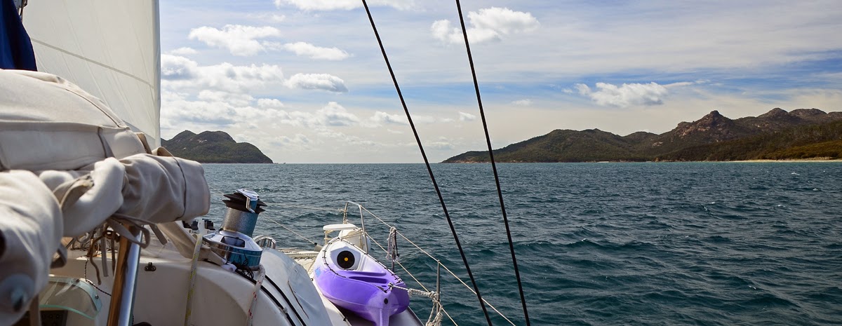
We were underway just after first light to motor-sail through Schouten
Passage, pausing for a short time to investigate the anchorages that we will
have to return to after our night in Wineglass Bay. To enter Wineglass Bay we
had to pass by the majestic Hazards, the Hazards Mountain Range in the Hazards
National Park on the Freycinet Peninsula which is another major tourist
attraction for Tasmania.
 |
| Lemon Rock off Cape Forestier, Freycinet Peninsula |
 |
| sailing into Wineglass Bay - The Hazards |
Wineglass Bay was not the isolated anchorage that I thought it would
be. There were four other boats besides AR, a large motorboat, a yellow Easy
design catamaran, a trimaran and a small monohull with an old fella on board, anchored
in the bay and a dozen or so people on the beach who had walked in from the top
car park. Nowhere in Tasmanian, in the places that we have been has there been
no one. It must be a sign of the modern times, the tourist times where more
people are out and about exploring the world.
 |
| Wineglass Bay |
The fellas from the motor boats had been out fishing for most of the
day and upon their return dropped by and gave a couple of good sized flathead
that MrJ and I had for dinner. How fresh was that! And how nice was that of
those fellas!
Late in the afternoon the wind changed to the NE and with that the
boats all swung round to put us on a very close lee shore. Nancy was not
comfortable...............!
Thank goodness the winds backed off and we were able to get a good
night’s sleep.
 |
| motorboat and The Hazards in the morning light |
Friday 28th Feb 2014:
.jpg) |
| there is always someone around to help eat the fish |
The NE winds were due to kick in again, this time much stronger. All
the boats in the Wineglass Bay anchorage were making a more to leave. First to
start their engines was the big motor boat, but they too were having a problem
with their anchor winch and it took some time for them to get this sorted. Next
to move was the old fella, a solo sailor, on the monohull. He was hoisting his
anchor manually, hand over hand, in between taking breaks to retire to the
cockpit, grab a drink and sit for a while before returning to his task. Keen!
MrJ and the old sailor did manage to exchange a few word before the mono sailed
out of the bay
The yellow catamaran moved next, helmed by another solo sailor. This
fella firstly moved closer to the tri, obviously stopping to confer before he
too sailed out without even a wave. MrJ and I followed short after leaving the
trimaran, a third solo sailor, to catch up much latter in the anchorage back through
Schouten Passage, around the corner of the Freycinet Peninsula, in Passage
Beach. Maybe all these three solo sailors were travelling together! I did
certainly hope so, for the old fella’s sake!
 |
| three's company |
 |
| nearing Schouten Passage - dolphins come running |
Passage Beach was a great anchorage for the
strong NE winds and contrary to what the good book says, we had no problem
anchoring and held firm all the time. AR and our fellow travellers form Wineglass
Bay were soon joined by many more boats coming into the safe anchorage, either
Passage Beach where we were or further inside in Bryans Corner. MrJ counted
eleven boats anchored nearby.
Early to bed and early to rise makes a man
healthy, wealthy and wise! (As Benjamin Franklin once said) The next day we
would be leaving for Flinders Island, the last of our Tasmanian stop-over’s.
 |
| the setting sun from Passage Beach |
.jpg)


.jpg)


.jpg)


.jpg)
.jpg)


.jpg)
