How many people get to live their dreams? I am..........!

This is my story from the time when Capt'n John and I first decided to sail around the big block, to circumnavigate this great land of ours, AUSTRALIA.


Sunday, 23 February 2014

Around Another Corner - Port Davey to Recherche Bay, Tasmania's South


Port Davey to Recherche Bay – Around Another Corner
Friday 7th February 2014
South West Cape
morning sun on the water
Up early in the dark and get ready to leave the beautiful Port Davey (Wilderness land forever). MrJ steers AR out past Breaksea Islands with only the outline of landform being viable, out to sea past all the rock island outcrops, past the East Pyramids. Leaving MrJ at the helm I went back to bed, I crawled back into my warm comfy bed till daylight broke through the hatch. I know, I felt sorry for MrJ too – for about 2 seconds – but he has always told me that it was not good for both of us to be on deck during the night hours unless some happens and who was I to argue when he volunteered to stay up. I woke to the day beginning and the vision through the cabin hatch of a big clear sky above the South West Cape. AR was now heading on a SE coarse to round the southern end of Tasmania. MrJ got some good sunrise photos!
People in Tasmania are never more than 115km from the coast. The nearest road to South West Cape is an unsealed road 61km away and it is also reported that South West Cape has the cleanest air in the world. Air over the Southern Ocean is typically thought of as the cleanest in the world in that the open Southern Ocean region is well removed from large sources of air pollution such as industrial areas, large cities etc.

Maatsuyker Island Group
seals at sea


I was totally surprised with the non-event seas; a less than 1mt swell and no wind waves because there was no wind and we were motoring with both motors to get anywhere. Out there in all that nothingness were a couple of seals lolling about on the surface, making the most of the dead flat conditions.
The day had by now settled in with a cover of light mist and a glassed out sea which reflected the daylight as far as the eye could see. Along the southern shore out of the mist, rose magnificent mountains and cliffs backed by the towering South Cape Range that extended for miles So “specky”, as my mate Glen would say.


passage between Flat Witch and De Witts Islands
AR was now approaching the Maatsuyker Island Group, one of the southernmost localities in Australia. There is a weather station on the southern end of Maatsuyker Island. We came upon a heap of craypot buoys that were spread across the channel on the northern side of Flat Witch Island. After navigating AR through all those buoys MrJ went for a rest while I took over the watch.

buoys with Flat Top & Round Tops Islands in the background
maybe this boats owned the buoys
There is one more island that is further south, Macquarie Island. It is grouped together with the other 333 islands that make up Tasmania. Macquarie Island being further south, lies in the southwest Pacific Ocean about half-way between New Zealand and Antarctica, at 54°30S, 158°57E. Politically, it is part of Tasmania since 1900 and became a Tasmanian State Reserve in 1978 and a World Heritage Site in 1997. The island is home to the entire Royal Penguin population on earth, during their annual nesting season. Macquarie Island has a weather monitoring station that records the cleanest air in the southern hemisphere.

Mewstone to the left - FlatTop and Round Top Island to the right
The southernmost south island that I did get to see through the mist was Mewstone (043’44.391S – 146’22.089E). Mewstone is an oval 13ha granite rock with steep cliffs and a small flat summit. It is an important breeding site for Shy Albatrosses. What little plant life there is grows in crevices in the rocks where soil has accumulated.
Maatsuyker Island with the Maatsukker Light House on the southern end
At Maatsuyker Island Lighthouse is Australia's most southerly lighthouse: conditions are usually extreme with the constant buffeting of the Roaring Forties coming off the Southern Ocean and it rains for 250 days per year. Today we were lucky; the sea was dead flat calm.

we get to see many large Albatross also cruising the oceans
AR was nearing South Cape when I thought we were being attacked by hundreds of dolphins.
Ha Ha ....not really! But we did have loads and loads of dolphins, come racing over to play between out hulls. As one pod would leave another pod was arriving; this went on for ages.
the dolphins came in from every direction 
jumping across the bow
between the hulls
mother and baby
going
going
gone
I didn't know which way to keep the camera facing, the dolphins were everywhere..................................!!!
a double act - the albatross get in on the action\
 South Cape, Soldier Bluff with the South Cape Range, Pindars Peak (1153m) , Precipitous Bluff (1029m)  and Mount La Perouse, to the left and Bare Hill , South East Cape and Whale Head to the right.
Inland from South Cape and South East Cape there are several mining exploits being undertaken.
The Rocky Boat Harbour Mineralized Area is an iridium and osmium mine on the banks of the Surprise Rivulet. The Rocky Plains Bay Field Mineralized Area is a coal mine just off the New River.
Other coal mines are the Recherche Bay Field Mineralized Area, The Catamaran Mineralized Area also known as the Old Mineralized Area, The Ida Bay Field Mineralized Area, The Benders Mine and the Anthracite Mine which has now been abandoned. The D'Entrecasteaux River Mineralized Area is a gold mine located on the banks of the D'Entrecasteaux River.
playing in the rain
By now the sky had thickened with dark clouds, the sound of thunder heralded the lightening and then as we rounded SE Cape the rain began. Of course this did not worry the dolphins. The rain went through flattening the sea; now the seals came out to play or rest on the surface.
even the seals were wanting in on the action
Our most southern point that we reached in AR was just off South East Cape (43’ 39.645S – 146’ 18.069E). South East Cape is the most southern point of Tasmania’s main island. 
We were headed for Recherche Bay, an anchorage called Coalbins in the southern bay called Rocky Bay. It had taken us 11.5hr to motor sail to Coalbins from Bramble Cove in Port Davey; a long day and it felt good to be at anchor again.

my calm evening

Wednesday, 19 February 2014

Port Davey - Tasmania's Wild South West

sailing into Port Davey at sunrise
Sunday 2nd Feb 2014:
Port Davey
Big Caroline & East Pyramids: big rocks and little rocks & islands on the S of the entrance to Port Davey
Port Davey is really divided into four sections; Outer Port Davey, Bathurst Channel, Bathurst Harbour and the Melaleuca River that opens into the Melaleuca Lagoon. First sighted by Abel Tasman in 1642 as he went past and visited by many explorers and ships over the centuries, then in 1798, Matthew Flinders with his friend George Bass circumnavigated Tasmania in the tiny Norfolk to prove that it was an island, charting only the outside of Port Davey on their way round.
passing the Breaksea Islands to get into the Bathurst Channel
boats anchored in Bramble cover under Mt Misery
“The accuracy with which the coastline generally is laid down by Flinders is very remarkable, considering the necessarily rough-and-ready nature of the survey mode by the Norfolk, which in the end had to hasten back to Sydney, owing to provisions running out, and the scantiness of his other sources. The most notable omissions are Macquarie Harbour and Port Davey, on the West Coast. Flinders noted the range of hills which runs down the eastern side of Macquarie Harbour (De Witt Range) and marks them as "high, woody hills, seen imperfectly through the haze," but he did not suspect the existence of the almost land locked inlet at their feet. He kept well off the coast at Port Davey, and simply notes on the chart, opening like a large river." – Excerpts taken from TROVE Digitised Newspapers and more http://trove.nla.gov.au/newspaper
Flinders, Bass and crew were becoming frustrated by the drawn-out monotony of the coastline they were skirting, which was desolate, dangerous and far from fascinating for these intrepid explorers. Flinders lack of enthusiasm for the coastal scenery of the west coast is apparent in the notes he made when sighting the rugged De Witt Range, north of what is now Port Davey - "The mountains which presented themselves to our view in this situation, both close to the shore and inland, were amongst the most stupendous works of nature I ever beheld, and it seemed to me are the most dismal and barren that can be imagined. The eye ranges over these peaks, and curiously formed lumps of adamantine rock, with astonishment and horror." From the book Flinders: The man who mapped Australia by Rob Mundle http://books.google.com.au/books?id=vYInHTQxSrkC&pg=PT127&lpg=PT127&dq=port+davey+bass+and+flinders&source=bl&ots=oURGs5w8PA&sig=LnvSEkA14aDCCKxBQWu8obggvfA&hl=en&sa=X&ei=r0YAU_LkMYq3lQWG7oHgBQ&ved=0CE8Q6AEwBA#v=onepage&q=port%20davey%20bass%20and%20flinders&f=false
What an awesome quote! The same could be said for the mountainous region within Port Davey - Dismal, barren, horrific – exactly what you want out of a cruising destination, right?

Mt Misery on a grey day 


Port Davey, Bathurst Channel and Bathurst Harbour are also dramatically beautiful, virtually untouched by man, having a fascinating indigenous and European history and they do provide a safe and indeed tranquil harbour from the ferocious Southern Ocean at its doorstep.


Port Davey is the last of the wilderness areas as far as cruising goes in Tasmanian water that there are no roads leading in only walking tracks and a small landing strip only suitable for light aircraft near the Ranger’s Stations and Kings Landing in the Melaleuca Lagoon. Port Davey is by no means the wild and lonely place it used to be in the King Family days (A book worth reading - King of the Wilderness : The Life of Deny King by Christobel Mattingley); it has many more visitors arriving by sea, air and on foot. During our short stay were saw a couple of light planes, six other yachts (including on other catamaran), a couple of light motorboats from the Melaleuca Lagoon area and a hiker.
Mt Rugby
raining in Clytie Cove
rainbow reflection - Clytie Cove looking towards Mt Parry and Mt Mackenzie 
The whole area has been declared a Marine Reserve which comes with a lot of regulations and restriction. Restriction like: where you can or cannot go in a powered dinghy, no discharge of any kind from any boat in the Bathurst Channel, no go zones for walking, diving, fishing and anchoring, and when going on hikes ashore the washing of footwear before landing and after returning to the dinghy due to the spread of the dreaded root rot (phytophthora) having been brought in on peoples shoes and camping gear. When doing any of the hikes ashore, especially to any of the high peaks, people are asked to tread lightly and use the existing wombat furrow tracks. There is very little top-soil over the underlying rock on the sides of the hills and slopes; it is quite easy in such a high rainfall area for an informal track to become a scar and to spoil the area. Biologists continue to discover new surprises in the dark brown water of the Port Davey waterway. This includes rare forms of coral and other marine life usually found in much deeper places in the Southern Ocean.
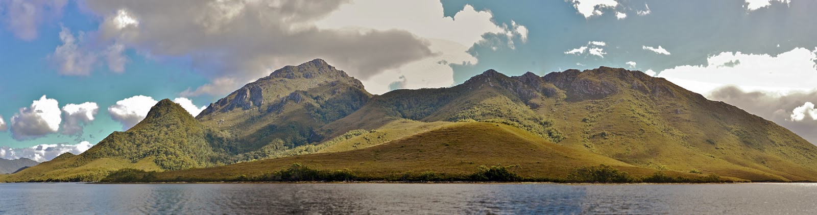
This region must surely be one of the most magnificent landscapes on the planet. Gold-green ranges, with bony quartzite ridges, rise sharply from the southern ocean and the broad interior waterways of Port Davey. Four major rivers and numerous creeks cut through gorges and snake across open plains, draining their rust-coloured waters into the marine reserve. Small islands dot the surface of the dark waters. White quartzite sands fringe the shoreline. Mt Rugby – the highest and most prominent peak bordering the reserve – rises grandly from the western shore of Bathurst Harbour. On a fine, calm day the marine reserve’s waters reflect the landscape to endless perfection. 
yacht passing under Mt Rugby
foul weather on the mountain
colourful evenings
The underwater landscape is even more surprising. In Bathurst Harbour and Bathurst Channel a very unusual marine environment has been created by a deep layer of dark red/brown, tannin-rich freshwater, which overlies tidal saltwater. The tannins restrict sunlight penetration to the top few metres, limiting the growth of marine plants. In their place live colourful and delicate marine invertebrates. In the clearer marine waters of Port Davey – away from the influence of the freshwater tannins – a more typical Tasmanian underwater world exists. Diverse kelp forests and abundant fish thrive beneath the surging Southern Ocean waves.
MrJ and I motor into Port Davey at first daylight with sunny skies, low swell and light winds; to pass south of the Breaksea Islands thus entering the Bathurst Channel. The channel is spectacular with the towering Mt Rugby to our port side and a long mountain range to our STB. There were a number of calm, protected and picturesque anchorages within the Channel to choose from. We decided on Clytie Cove (43'20.910S / 146'05.615E) as the best anchorage for us in the southerly winds as it had been reported to have good holding. Clytie Cove proved to be great for our stay. MrJ and I had the anchorage all to ourselves and for those couple of days we had a somewhat surreal feeling that we were the only people for hundreds of kilometres. There could have been a major disaster going on somewhere and we would have had no idea. There was no phone service, no radio station coverage even no VHF radio reception. All we could get was a recorded weather report for the entire area of the SW Tasmanian coast, twice per day on the HF radio. Better than the nothing the early explores would have had.

trekking the ridge
nature's wonders
MrJ chats with the Swiss hiker
Bathurst Channel - look, there's Alana Rose anchored on the right side in Clytie Cove
there's that yacht again  tucked up in Iola Bay

here is Alana Rose entering Bathurst Harbour
Bathurst Harbour - looking back at the Rugby Range 
inside Bathurst Harbour
Bathurst Harbour looking north

Melaleuca Inlet, left - Claytons Corner, right
the jetty in Claytons Corner
MrJ and I saw only a handful of boats pass up and down the channel. The only time we shared an anchorage was when we moved AR out to Bramble Cove (43'19.357S / 146'00189E) a couple of day before we left Port Davey.
The only people we spoke to in person were a fella from Switzerland who was travelling the Port Davey to Southern Ocean Overland Track, when we went for our own hike up one of the smaller ridges, and a French couple on a yellow sloop when we moved AR into Bramble Cove where we did walks on the beach.
The weather was reasonable for where we were located; cool, windy and raining some of the time with beautiful sunny days with still air to bring out the best of the gorgeous reflections on the calm water other times. I spent rainy times baking bread or making casseroles to keep the cabin warm! Yet every day I would step outside and be completely blown away by the breathtaking beauty that surrounded me.

Bramble Cove
the French yacht

maintenance work
looking towards the Breaksea Island from Bramble Cove at Sunset

on the beach

in the sand
more maintenance work in exotic places
Bramble Cove
We were lucky to be in Port Davey in settled weather; in foul windy weather there is always wind funneling out of Joe Page Bay, and between Mt Rugby and the steep high ridges of Mt Beattie on the southern side of the channel – Although reading the guide book, the only safe anchorage in W gale conditions would be in the bay on the south side of Kings Point in Bathurst Harbour. This anchorage maybe a little drafty but is reported to have excellent holding.
MrJ and I had only scratched the surface of exploring this spectacular, special place.
Clytie Cove with the Pasco Range behind